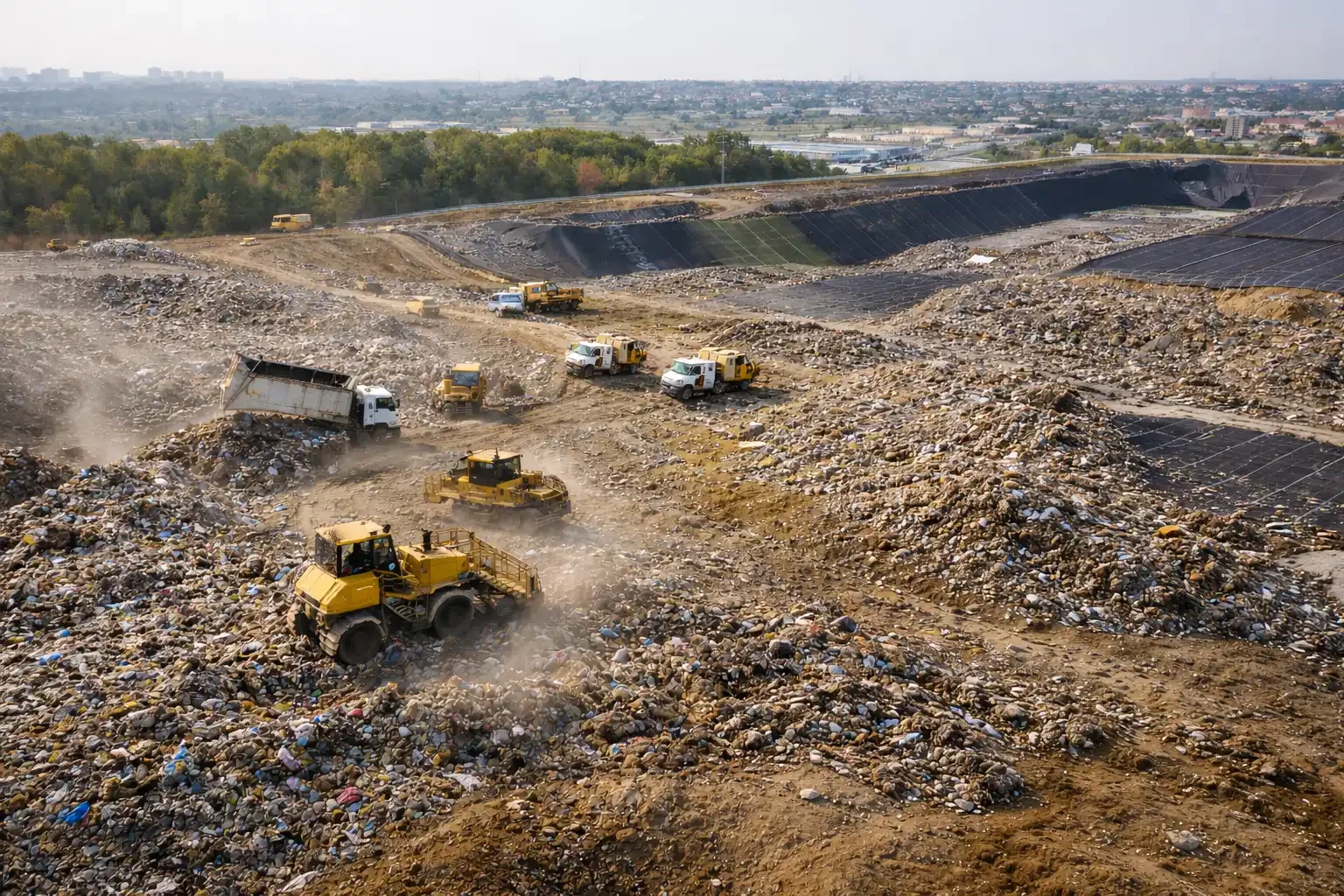
Landfill & Waste Management Drone Survey | Volume Measurement, LiDAR & Compliance
Aeroyantra delivers survey-grade landfill and waste management drone mapping and LiDAR - accurate waste volume measurement, landfill cell tracking, leachate and drainage monitoring, and compliance-ready documentation without requiring personnel to enter active waste areas.
Table Of Content
- Landfill & Waste Management Drone Survey for Volume Measurement, Airspace and Compliance
- Landfill Operations Are Making Critical Decisions on Volume Data That Is Months Out of Date
- Survey-Grade Drone and LiDAR Data for Every Critical Landfill Measurement - Without Ground Access
- Replace Estimates With Measurements. Bill Accurately. Report Confidently.
- Know Exactly How Much Landfill Airspace You Have Left - Before You Run Out
- Track Every Cell. Document Every Phase. Never Lose the Record.
- Detect Leachate Ponding and Drainage Failures Before They Become Environmental Incidents
- LiDAR for Landfills - Precision Where Surface Complexity Defeats Photogrammetry
- Compliance Reports That Hold Up - Generated From Measured Data, Not Estimates
- Thermal Imaging - Detect Subsurface Hot Spots and Gas Migration Before They Escalate
- Complete Deliverables by Operational Need
- Who Uses Aeroyantra for Waste Management and Landfill Operations
- Frequently Asked Questions
- Ready to Replace Landfill Volume Estimates With Measurements You Can Defend?
Landfill & Waste Management Drone Survey for Volume Measurement, Airspace and Compliance
Landfill operations run on volume data that is routinely inaccurate, collected at risk to survey personnel, and assembled too infrequently to support operational decisions or regulatory compliance.
Aeroyantra is a landfill and waste management drone survey and LiDAR platform built for volume measurement, airspace calculation, environmental monitoring, and regulatory compliance. Aeroyantra delivers survey-grade drone mapping and LiDAR for waste management facilities - accurate waste volume measurement, landfill cell tracking, leachate and drainage monitoring, and compliance-ready documentation generated from aerial data without requiring personnel to enter active waste areas.
Landfill Operations Are Making Critical Decisions on Volume Data That Is Months Out of Date
Waste management operators, municipal bodies, and regulatory agencies face a consistent data problem: the volume of waste in a landfill cell, the remaining airspace capacity, and the rate of fill progression are all numbers that matter enormously - and are almost never known accurately.
The consequences play out predictably across landfill operations of every scale:
-
Remaining capacity is underestimated or overestimated - Leading to premature cell closure, unplanned capacity procurement, or regulatory violations when permitted volumes are exceeded
-
Survey personnel are exposed to unnecessary risk - Ground-level surveys in active waste areas expose crews to hazardous materials, unstable surfaces, and poor air quality
-
Compliance reporting is assembled reactively - Volume reports submitted to regulatory bodies are derived from manual estimates rather than measured data, creating legal exposure when disputed
-
Leachate and drainage issues are detected late - Ponding, drainage blockage, and leachate migration are not visible from ground level until they become significant environmental incidents
-
Closure planning is based on inaccurate airspace data - Landfill closure and post-closure monitoring programs built on inaccurate volume baselines produce cost overruns and regulatory non-compliance
-
Cell progression is tracked manually - Without consistent aerial monitoring, operators cannot accurately measure fill rates, project closure dates, or demonstrate compliance with cell sequencing plans
The problem is not a lack of operational diligence. It is a fundamental limitation of ground-level survey methods in an environment where ground-level access is hazardous, inconsistent, and inherently inaccurate.
Survey-Grade Drone and LiDAR Data for Every Critical Landfill Measurement - Without Ground Access
Aeroyantra delivers drone mapping and LiDAR workflows that produce accurate, defensible volume measurements, cell tracking data, and compliance documentation from aerial surveys - without requiring survey personnel to enter active waste areas.
With RTK, PPK, and GCP-supported workflows, Aeroyantra achieves 2-3 cm horizontal accuracy and vertical precision suitable for waste volume measurement, airspace calculation, and regulatory reporting.
What that means for landfill operations:
-
Accurate waste volumes - Measured from aerial data, not estimated from manual counts or compaction factors
-
Remaining airspace quantified - Precise calculation of remaining permitted capacity against design cell geometry
-
Personnel safety preserved - All survey data collected from drone altitude - no ground access to active waste areas required
-
Compliance-ready reports - Georeferenced, time-stamped volume and condition reports formatted for regulatory submission
-
Leachate and drainage visibility - Aerial identification of ponding, drainage blockage, and surface condition issues before they become environmental incidents
-
Time-series cell tracking - Repeat surveys registered to a common datum, enabling accurate fill rate calculation and closure date projection
Replace Estimates With Measurements. Bill Accurately. Report Confidently.
Waste volume estimation from manual methods - compaction factor calculations, truck count multipliers, and infrequent ground surveys - introduces variance that compounds over time and creates legal exposure when regulatory reports are disputed.
This replaces manual landfill volume estimation with measured, audit-ready 3D surface data from drone and LiDAR surveys. Aeroyantra replaces estimation with measurement. Each drone survey produces a Digital Surface Model of the active waste area that is compared against the previous survey and the permitted cell design to produce accurate, defensible volume data.
What Aeroyantra delivers for waste volume measurement:
-
Total waste volume in place - Quantified volume of waste in each active cell derived from surface model comparison against the baseline or design geometry
-
Incremental volume added - Volume of waste deposited between survey cycles, enabling accurate fill rate calculation and billing reconciliation
-
Compaction rate analysis - Surface settlement monitoring between survey cycles to measure actual compaction rates against design assumptions
-
Cell-by-cell volume breakdown - Separate volume calculations for each active and closed cell within the facility
-
Waste face geometry - Precise mapping of the active waste face, including slope angles, bench geometry, and working face dimensions
-
Design-to-actual comparison - Current waste surface compared against permitted cell design to identify areas approaching permitted limits
-
Tonnage reconciliation - Volume data combined with waste density factors to reconcile measured volumes against weighbridge tonnage records
Technical Performance:
| Parameter | Specification |
|---|---|
| Georeferencing | RTK, PPK, GCP-supported |
| Horizontal accuracy | 2-3 cm under proper survey standards |
| Vertical accuracy | Suitable for volume and airspace calculation |
| Volume accuracy | Within 1-2% for well-defined waste areas |
| Survey frequency | Weekly, monthly, or quarterly - configurable |
| Output formats | GeoTIFF, LAS, DXF, SHP, PDF - GIS compatible |
Know Exactly How Much Landfill Airspace You Have Left - Before You Run Out
Remaining airspace is the single most operationally critical number in landfill management. When it is wrong, the consequences range from premature cell closure to regulatory violation. When it is right, operators can plan cell sequencing, procurement, and closure programs with confidence.
Airspace calculation from drone survey data gives operators a defensible basis for capacity planning and regulatory reporting. Aeroyantra calculates remaining airspace from the difference between the current waste surface and the permitted cell design geometry - producing an accurate, defensible number at every survey cycle.
What Aeroyantra delivers for airspace management:
-
Remaining airspace volume - Precise calculation of remaining permitted capacity in each active cell, updated at every survey cycle
-
Fill rate projection - Historical fill rate data used to project remaining operational life and closure date for each cell
-
Airspace consumption rate - Monthly and annual airspace consumption rates for operational planning and regulatory reporting
-
Cell sequencing support - Spatial data showing fill progression across cells to support sequencing decisions and new cell opening planning
-
Permit compliance monitoring - Continuous comparison of current waste surface against permitted maximum elevation contours, with flagging when approaching permitted limits
-
Closure timeline projection - Data-driven closure date projection based on measured fill rates and remaining airspace
Track Every Cell. Document Every Phase. Never Lose the Record.
Landfill operations involve multiple cells at different stages - active filling, intermediate cover, final cover, and post-closure monitoring. Managing this complexity without a consistent aerial record produces gaps in documentation that create regulatory and legal exposure.
Aeroyantra standardizes repeat aerial surveys across the full facility, producing a time-series record of cell progression that covers every phase of the landfill lifecycle.
What Aeroyantra delivers for cell tracking:
-
Active cell progression mapping - Weekly or monthly orthomosaics showing waste face advancement, bench development, and working area extent
-
Intermediate cover verification - Aerial confirmation that intermediate cover has been applied at the correct thickness and extent across completed waste areas
-
Final cover monitoring - Surface condition monitoring of final cover layers, including settlement detection, erosion identification, and vegetation establishment tracking
-
Cell boundary documentation - Georeferenced record of cell boundaries, liner extents, and permitted limits at every survey cycle
-
Multi-cell facility overview - Single-flight coverage of the entire facility producing a current condition record across all active and closed cells simultaneously
-
Time-series progression archive - Complete chronological record of cell development from opening to closure, preserved as a georeferenced, time-stamped dataset
Detect Leachate Ponding and Drainage Failures Before They Become Environmental Incidents
Leachate management failures and drainage blockages are among the most serious operational and environmental risks in landfill management. They are also among the hardest to detect from ground level until they have already become significant problems.
Aerial monitoring changes the detection timeline. Ponding, drainage blockage, leachate migration, and surface condition anomalies are visible from drone altitude before they are visible - or accessible - from the ground.
What Aeroyantra delivers for environmental monitoring:
-
Leachate ponding detection - Identification of surface water and leachate accumulation on active and closed cell areas from high-resolution aerial imagery
-
Drainage channel condition mapping - Aerial mapping of perimeter and internal drainage channels, identifying blockages, erosion, and structural failures
-
Surface condition anomaly detection - Identification of subsidence, cracking, slope failures, and surface irregularities on intermediate and final cover areas
-
Stormwater management monitoring - Aerial assessment of stormwater diversion bunds, channels, and detention areas across the facility
-
Perimeter and boundary monitoring - Regular aerial record of facility perimeter conditions, access roads, and boundary fencing for operational and security compliance
-
Vegetation and erosion monitoring - Tracking of vegetation establishment on closed cells and identification of erosion on cover slopes and embankments
-
Post-incident documentation - Rapid aerial assessment of environmental incidents - slope failures, leachate breakouts, fire events - for regulatory reporting and remediation planning
LiDAR for Landfills - Precision Where Surface Complexity Defeats Photogrammetry
Active waste areas present a specific photogrammetric challenge: irregular, highly textured surfaces with poor feature matching characteristics, steep waste faces, and deep shadow zones between waste piles. In these conditions, photogrammetry point clouds introduce errors that affect volume accuracy.
LiDAR eliminates this problem. The active scanning geometry of LiDAR sensors captures accurate surface data regardless of texture, shadow, or surface irregularity - producing volume measurements you can defend in a regulatory audit.
What Aeroyantra delivers from LiDAR landfill surveys:
-
High-accuracy waste surface model - Dense, accurate point cloud of the active waste surface including steep faces, irregular geometry, and shadowed areas that photogrammetry handles poorly
-
Subsidence and settlement monitoring - Millimeter-level surface change detection on closed cells and final cover areas, enabling early identification of differential settlement and structural issues
-
Slope stability data - Precise waste face slope angles and geometry for geotechnical assessment and stability monitoring
-
Underground gas infrastructure mapping - LiDAR capture of landfill gas collection pipe networks, wellheads, and surface infrastructure for asset management
-
Leachate collection system mapping - Surface mapping of leachate collection infrastructure, manholes, and drainage outlets for maintenance planning
-
High-accuracy volume calculation - LiDAR-derived volume calculations for regulatory submissions where photogrammetry accuracy is insufficient
-
Liner and base geometry - Pre-waste LiDAR survey of cell liner geometry for baseline airspace calculation before filling begins
Compliance Reports That Hold Up - Generated From Measured Data, Not Estimates
Regulatory compliance in landfill operations depends on volume data, condition records, and environmental monitoring reports that are accurate, traceable, and defensible. Reports assembled from manual estimates and infrequent ground surveys do not meet this standard when scrutinized.
This creates a time-series, georeferenced compliance record suitable for regulatory audits. Aeroyantra produces compliance documentation from georeferenced, time-stamped aerial data - giving operators reports that are accurate, auditable, and ready for regulatory submission.
What Aeroyantra delivers for compliance:
-
Volume compliance reports - Quantified waste volume reports showing current volumes, incremental additions, and remaining airspace against permitted limits - formatted for regulatory submission
-
Cell condition reports - Aerial condition assessment of active, intermediate cover, and final cover areas with annotated imagery and georeferenced issue flags
-
Operational boundary compliance - Verification that waste placement remains within permitted cell boundaries and below permitted maximum elevations
-
Environmental monitoring records - Georeferenced, time-stamped aerial records of leachate, drainage, and surface condition for environmental compliance files
-
Closure and post-closure documentation - Aerial record of closure activities, final cover installation, and post-closure surface condition for regulatory handover packages
-
Incident documentation - Rapid aerial assessment reports for environmental incidents, formatted for regulatory notification and remediation planning
-
Audit-ready archive - Complete chronological aerial record of facility operations, accessible and exportable for regulatory audit at any time
Thermal Imaging - Detect Subsurface Hot Spots and Gas Migration Before They Escalate
Landfill fires and uncontrolled landfill gas migration are among the most serious operational and safety risks in waste management. Subsurface combustion and gas accumulation are frequently invisible at the surface until they have reached a dangerous level.
Thermal payload integration with Aeroyantra drone surveys adds a critical detection layer to standard aerial monitoring.
What thermal monitoring delivers for landfill operations:
-
Subsurface hot spot detection - Thermal anomalies on the waste surface indicating subsurface combustion or elevated gas oxidation activity, identified before visible smoke or flame
-
Landfill gas migration mapping - Thermal contrast mapping of gas migration pathways and surface emission points across the waste body and cover areas
-
Active fire perimeter mapping - Precise thermal mapping of fire perimeters on active landfill fires for emergency response coordination and post-incident documentation
-
Cover integrity assessment - Thermal detection of cover layer failures where gas or heat is escaping through compromised intermediate or final cover
-
Leachate temperature anomalies - Thermal identification of leachate accumulation and migration pathways from temperature contrast with surrounding waste and cover material
Complete Deliverables by Operational Need
| Deliverable | Volume Measurement | Airspace | Cell Tracking | Environmental | Compliance |
|---|---|---|---|---|---|
| High-res orthomosaic | ✓ | ✓ | ✓ | ✓ | ✓ |
| Digital Surface Model (DSM) | ✓ | ✓ | ✓ | - | ✓ |
| Waste volume report | ✓ | ✓ | - | - | ✓ |
| Remaining airspace calculation | - | ✓ | - | - | ✓ |
| Fill rate projection | - | ✓ | ✓ | - | ✓ |
| Cell progression record | - | - | ✓ | - | ✓ |
| Leachate ponding detection | - | - | - | ✓ | ✓ |
| Drainage condition report | - | - | - | ✓ | ✓ |
| LiDAR point cloud (LAS/LAZ) | ✓ | ✓ | - | - | ✓ |
| Slope stability data | ✓ | - | - | ✓ | ✓ |
| Thermal hot spot report | - | - | - | ✓ | ✓ |
| Compliance report package | - | - | - | - | ✓ |
| Time-series archive | ✓ | ✓ | ✓ | ✓ | ✓ |
Who Uses Aeroyantra for Waste Management and Landfill Operations
Aeroyantra is used by landfill operators, municipal solid waste agencies, environmental compliance teams, and waste management contractors managing:
- Municipal solid waste landfills under regulatory compliance requirements
- Industrial and hazardous waste disposal facilities requiring precise volume documentation
- Construction and demolition waste processing and disposal sites
- Legacy landfill remediation and closure programs
- Waste-to-energy facility site planning and monitoring
- Regional sanitary landfill development and operational monitoring
- Post-closure landfill monitoring and maintenance programs
- Environmental consultants preparing compliance submissions and audit documentation
Frequently Asked Questions
Q1: How accurate is drone-based waste volume measurement compared to manual methods?
With RTK or PPK georeferencing, Aeroyantra achieves waste volume accuracy within 1-2% for well-defined landfill cell areas. Manual estimation methods - compaction factor calculations and truck count multipliers - routinely introduce variance of 10-20% or more. For regulatory reporting purposes, drone-derived volume measurements are significantly more defensible than manual estimates because they are based on measured surface geometry rather than assumed factors.
Q2: Do survey personnel need to enter the active waste area for drone surveys?
No. All survey data is collected from drone altitude. Survey personnel operate from outside the active waste area - typically from the facility perimeter or a designated safe operating zone. This eliminates the need for confined space entry, hazardous material exposure, and the safety risks associated with ground-level survey on active waste faces.
Q3: How frequently should landfill volume surveys be conducted?
Survey frequency depends on operational requirements and regulatory obligations. For active landfills receiving high volumes, monthly surveys are standard for operational management and billing reconciliation. Quarterly surveys are typical for regulatory compliance reporting. For closed cells under post-closure monitoring, annual surveys are generally sufficient for settlement and cover condition monitoring. Aeroyantra supports any survey frequency from weekly to annual.
Q4: Can Aeroyantra produce reports in a format accepted by regulatory authorities?
Aeroyantra produces georeferenced, time-stamped volume reports and condition assessments with all data traceable to the aerial survey source. Report formatting for specific regulatory submission requirements can be configured to match the documentation standards of environmental regulatory authorities. We recommend confirming specific format requirements with your compliance team before the first survey cycle.
Q5: Can drone surveys detect leachate problems that are not yet visible from the ground?
Yes. High-resolution aerial imagery identifies surface water and leachate accumulation, drainage channel blockages, and cover condition anomalies that are not visible from ground level until they have already become significant. Thermal payload integration adds a further detection layer, identifying temperature anomalies associated with leachate accumulation and subsurface gas activity before surface symptoms appear.
Q6: How does Aeroyantra handle the irregular and textured surface of active waste areas?
For highly irregular waste surfaces with steep faces and deep shadow zones, Aeroyantra recommends LiDAR workflows rather than photogrammetry. LiDAR active scanning geometry captures accurate surface data regardless of surface texture, shadow, or irregularity - producing volume measurements that are more accurate than photogrammetry in challenging waste face conditions. For flatter, more uniform waste areas, photogrammetry delivers sufficient accuracy at lower cost.
Q7: Can Aeroyantra support legacy landfill closure and post-closure monitoring programs?
Yes. Legacy landfill closure programs require accurate baseline volume surveys, cover installation verification, settlement monitoring, and long-term post-closure condition records. Aeroyantra supports all of these with repeat aerial surveys registered to a common datum - producing a time-series record of settlement, vegetation establishment, and surface condition that satisfies post-closure monitoring requirements.
Q8: What happens if the landfill site is in a restricted airspace zone?
Operations near restricted airspace - airports, military zones, and certain urban areas - require prior permission through local aviation regulatory platforms. Aeroyantra provides technical support for flight planning within approved operational parameters. Regulatory clearance coordination is the responsibility of the client's operational team. Most landfill sites outside major urban centers fall within permissible airspace for drone operations under standard approvals.
Ready to Replace Landfill Volume Estimates With Measurements You Can Defend?
Whether you are managing active cell operations, regulatory compliance, environmental monitoring, or closure planning, Aeroyantra delivers the aerial data your waste management teams need - accurately, safely, and on a schedule that matches your operational requirements.
Other Industries We Serve
Discover how Aeroyantra delivers survey-grade drone mapping across different sectors
Mining & Quarrying
Stockpile volumes, pit progression, and compliance documentation
Construction
Earthworks monitoring, cut/fill analysis, and as-built verification
Roads & Highways
Corridor mapping, alignment verification, and progress tracking
Rail & Linear Infrastructure
Corridor monitoring, embankment tracking, and ROW verification
Industrial & EPC
Site planning, structural inspection, and facility documentation
Smart City & Urban Works
Urban planning, land use monitoring, and GIS mapping
Agriculture
Precision farming, crop monitoring, and irrigation planning
Oil & Gas
Pipeline monitoring, facility inspection, and thermal imaging
Solar
Panel inspection, performance monitoring, and hot spot detection
Owners & Developers
Independent progress verification and quantity validation