Rail & Linear Infrastructure Drone Survey | Corridor Monitoring, LiDAR & Alignment
Aeroyantra delivers survey-grade rail and linear infrastructure drone surveys with LiDAR. Validate earthwork quantities, detect alignment drift, and maintain audit-ready corridor records across every phase of the project lifecycle.
Table Of Content
- Rail & Linear Infrastructure Drone Survey: Rail Corridor Monitoring That Catches Problems Before They Cost You
- In Multi-Kilometer Rail Corridors, the Gap Between Survey Cycles Is Where Risk Accumulates
- Engineered for Rail and Linear Infrastructure Corridor Monitoring. Not Adapted for It.
- Drone Photogrammetry for Rail and Linear Infrastructure Corridors
- LiDAR for Rail Corridors - What Photogrammetry Cannot See
- LiDAR for Powerline and Transmission Line Corridor Inspection
- Photogrammetry or LiDAR for Corridor Mapping - How to Choose the Right Workflow
- Who Uses Aeroyantra for Rail and Linear Infrastructure Corridor Projects
- Frequently Asked Questions
- Ready to Bring Survey-Grade Aerial Intelligence to Your Rail Corridor?
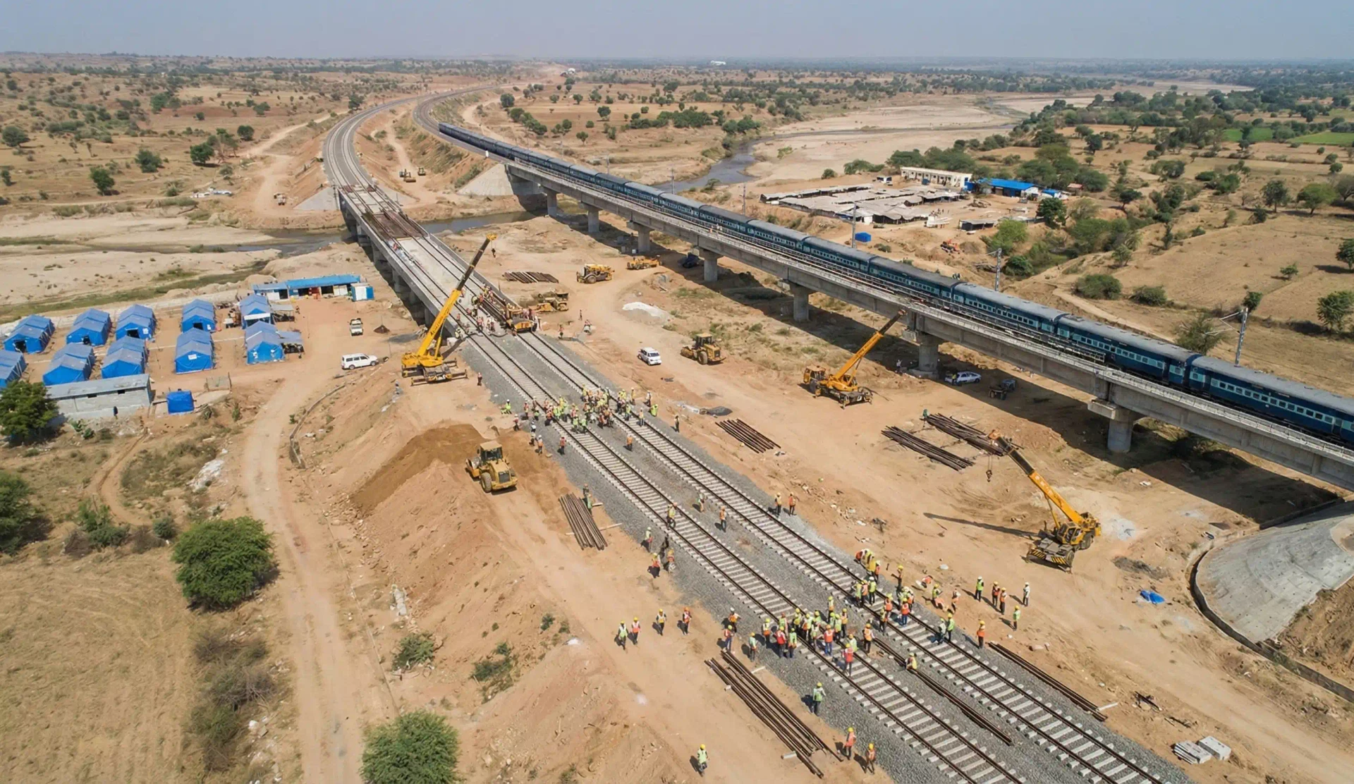
Rail & Linear Infrastructure Drone Survey: Rail Corridor Monitoring That Catches Problems Before They Cost You
Aeroyantra is a rail and linear infrastructure drone survey and LiDAR corridor mapping platform built for repeatable, audit-ready engineering measurement. Aeroyantra delivers survey-grade drone mapping and LiDAR intelligence for large-scale rail corridors and linear infrastructure - so your teams can validate earthwork quantities, detect alignment drift, and maintain audit-ready records across every phase of the project lifecycle.
Most infrastructure delays are not caused by effort. They are caused by delayed visibility.
In Multi-Kilometer Rail Corridors, the Gap Between Survey Cycles Is Where Risk Accumulates
Traditional ground survey methods cannot keep pace with active rail construction. The result is a predictable failure pattern that plays out on corridor projects worldwide.
The pattern looks like this:
-
Slow mobilization across long, active corridors
-
Inconsistent data quality between survey intervals
-
Late identification of alignment deviation and embankment slippage
-
Manual reconciliation of earthwork quantities against billing schedules
-
Billing disputes that emerge after the window to act has closed
-
No structured time-series record for regulatory or contractual disputes
By the time a discrepancy surfaces, corrective work is already underway - and so is the dispute.
Engineered for Rail and Linear Infrastructure Corridor Monitoring. Not Adapted for It.
General-purpose drone platforms are built for flexibility. Aeroyantra is built for the specific demands of rail corridors and linear infrastructure - where measurement accuracy, workflow repeatability, and compliance documentation are non-negotiable.
With RTK, PPK, and GCP-supported workflows, Aeroyantra supports 2-3 cm horizontal accuracy and reliable vertical precision, making it suitable for earthwork validation, alignment monitoring, and quantity reconciliation across multi-kilometer corridors.
What that means in practice:
-
Earthwork validation you can bill from - Cut-and-fill reports derived from survey-grade surface models, not estimated volumes
-
Alignment monitoring across the full corridor - Time-series comparisons that flag drift before it requires corrective regrading
-
Audit-ready records at every milestone - Georeferenced, time-stamped outputs that satisfy regulatory and contractual documentation requirements
-
No software installation for stakeholders - Share 3D models and orthomosaics via browser-based viewer, accessible to any team member or client
-
Local technical support - Technical support aligned with project requirements and operational standards
Drone Photogrammetry for Rail and Linear Infrastructure Corridors
Aeroyantra standardizes repeatable photogrammetric survey workflows for rail corridor monitoring. Flights are planned at optimized GSD configurations for corridor-scale linear mapping, with RTK, PPK, or GCP-based georeferencing depending on project requirements.
This workflow supports corridor-scale drone mapping for earthworks validation, alignment verification, and right-of-way monitoring.
Each photogrammetry mission delivers:
-
High-resolution orthomosaics - True-color aerial imagery georeferenced to survey-grade accuracy, suitable for engineering review and stakeholder reporting
-
Digital Surface Models and Digital Terrain Models - Surface and bare-earth models for earthwork analysis and grading validation
-
Cut-and-fill volume reports - Quantified earthwork calculations derived from surface model comparisons, suitable for billing validation and contractor reconciliation
-
Time-series progress comparisons - Repeat surveys registered to a common datum, enabling detection of terrain change, settlement, and construction progress between monitoring cycles
-
Contour generation - Engineering-grade contour data at user-defined intervals for design validation and drainage analysis
-
Encroachment and boundary detection - Identification of structures, vegetation, and material encroachment into the right-of-way
-
Georeferenced, time-stamped records - Audit-ready documentation at every survey milestone
Technical Performance:
| Parameter | Specification |
|---|---|
| Georeferencing | RTK, PPK, GCP-supported |
| Horizontal accuracy | 2-3 cm under proper survey standards |
| Vertical accuracy | Suitable for earthwork and grading validation |
| Output formats | GeoTIFF, LAS, DXF, SHP - compatible with AutoCAD Civil 3D, Bentley OpenRail, GIS platforms |
| Viewer | Browser-based 3D viewer, no installation required |
LiDAR for Rail Corridors - What Photogrammetry Cannot See
Photogrammetry gives you surface models. LiDAR gives you the full three-dimensional structure of a corridor - including what the camera cannot reach.
LiDAR corridor mapping enables precise alignment verification, contact wire geometry measurement, and embankment profiling at scale. Vegetation canopy conceals embankment geometry. Track furniture obscures ballast profiles. Overhead electrification geometry - contact wire height, stagger, and sag - is invisible to RGB-only workflows. LiDAR penetrates through foliage, captures wire catenary profiles, and produces classified point clouds that drive engineering decisions, not just visual reports.
The LiDAR Workflow
1. Flight planning and sensor configuration Missions planned at 50-80 m AGL with optimized flight lines for corridor geometry. Point density targets 100+ points per square meter. RTK-enabled IMU/GNSS integration ensures accurate direct georeferencing.
2. Data acquisition Dense, calibrated point cloud captured across the corridor. A single LiDAR mission covers 50+ km of corridor per day - replacing multi-week ground survey cycles without track possession or service disruption.
3. Point cloud processing and classification Raw data processed through automated classification pipelines. Returns separated into ground, vegetation, structures, track furniture, and overhead wire classes.
4. Feature extraction and analysis Classified point clouds used to extract track alignment profiles, contact wire geometry, embankment cross-sections, and terrain change surfaces.
5. Deliverable generation and export Final outputs exported in LAS/LAZ, DXF, SHP, and formats compatible with AutoCAD Civil 3D, Bentley OpenRail, and GIS platforms.
What Aeroyantra Extracts from LiDAR Railway Surveys
-
Bare-earth DTM extraction - Ground surface models revealing true terrain beneath canopy cover
-
Track alignment and geometry analysis - Horizontal and vertical alignment profiles for deviation detection and engineering validation
-
Contact wire height and stagger measurement - Overhead electrification geometry at measurable intervals along the corridor
-
Ballast and embankment profiling - Cross-sectional analysis of ballast geometry and embankment slope condition
-
Rockfall and obstruction detection - Material encroachment identification into the right-of-way
-
Bridge and structure clearance measurement - Precise clearance at bridges, underpasses, and overhead structures
-
Landslide and slope instability monitoring - Time-series detection of terrain movement, slope creep, and embankment settlement
-
Drainage and waterway mapping - Profiling of drainage channels, culverts, and water crossings
-
Time-series change detection - Repeat surveys enabling detection of terrain change, settlement, and alignment drift
-
Feature extraction for BIM and Civil 3D - Classified point cloud exports compatible with engineering platforms
LiDAR for Powerline and Transmission Line Corridor Inspection
Transmission infrastructure spans hundreds of kilometers across terrain that is often inaccessible, densely vegetated, and operationally hazardous for ground crews. Traditional inspection methods - helicopters, climbing teams, vehicle patrols - are expensive, slow, and unable to produce the structured spatial data that modern asset management requires.
This replaces helicopter patrols with drone LiDAR powerline corridor inspection and clearance analysis. Drone LiDAR changes the economics and the output quality of powerline inspection entirely.
The Powerline LiDAR Workflow
1. Corridor planning and regulatory clearance Flight corridors planned along the transmission line route with appropriate buffer zones. Sensor configuration optimized for thin wire detection and vegetation penetration.
2. Multi-return LiDAR acquisition Multi-return sensors capture multiple returns per laser pulse - critical for distinguishing conductors, insulators, and vegetation within the same scan line. Wire detection requires minimum 100 pts/m2 at conductor level.
3. Wire and vegetation classification Point cloud classification separates conductors, ground wires, insulators, tower structures, and vegetation into discrete classes.
4. Clearance analysis and risk zoning Conductor-to-vegetation and conductor-to-structure clearance distances measured at defined intervals. Risk zones classified by threshold: critical (under 3 m), high (3-5 m), moderate (5-7.5 m), monitored (7.5-10 m).
5. Reporting and field crew dispatch Georeferenced clearance reports delivered with GPS coordinates, vegetation classification, and risk severity - replacing blanket corridor clearing with targeted, prioritized intervention.
What Aeroyantra Delivers from Powerline LiDAR Surveys
-
Conductor catenary modeling - Precise 3D wire geometry including sag measurement under varying load conditions
-
Clearance analysis - Automated conductor-to-vegetation and conductor-to-structure clearance with tiered risk classification
-
Vegetation encroachment detection - Georeferenced identification of encroaching trees and overgrowth with field crew dispatch coordinates
-
Tower and structure inspection - Point cloud capture of tower geometry, insulator positions, and structural deformation
-
Right-of-way corridor mapping - Full 3D model of terrain, structures, vegetation, and wire geometry in a single dataset
-
Fault and damage assessment - Post-event inspection for ice loading, storm damage, fire exposure, and breakage
-
Vegetation management planning - Prioritized clearance reports replacing blanket clearing with targeted intervention
-
Sag and tension analysis - Conductor sag profiles measured at span level, compared against design parameters
A single drone LiDAR mission can scan and process 52+ km of transmission line in under two hours - compared to days or weeks using conventional methods.
Photogrammetry or LiDAR for Corridor Mapping - How to Choose the Right Workflow
Both workflows are available through Aeroyantra. The right choice depends on your corridor environment, deliverable requirements, and budget.
| Factor | Photogrammetry | LiDAR |
|---|---|---|
| Canopy penetration | Surface only | Full penetration to bare earth |
| Wire and conductor detection | Unreliable | Precise - multi-return capture |
| Horizontal accuracy | 2-3 cm (RTK/PPK) | 1-2 cm |
| Visual output | High-resolution RGB imagery | Point cloud with colorization |
| Cost | Lower | Higher |
| Best for | Open corridor earthworks, quantity validation, progress monitoring | Canopy-covered terrain, electrification geometry, powerline inspection |
| Combined workflow | Yes - fused dataset available | Yes - geometry + visual context |
For most rail corridor projects, Aeroyantra recommends a fused workflow - LiDAR for geometric precision and canopy penetration, photogrammetry for high-resolution visual context - delivered as a single unified dataset.
Who Uses Aeroyantra for Rail and Linear Infrastructure Corridor Projects
Aeroyantra is used by project managers, survey teams, infrastructure contractors, and asset owners managing:
- Active rail corridor construction and monitoring
- High-speed rail and metro corridor feasibility and detailed design support
- Industrial earthworks and grading validation
- Quantity reconciliation before billing milestones
- Regulatory documentation across the full project lifecycle
- Transmission line inspection and vegetation management
- Right-of-way encroachment detection and boundary documentation
- Post-disaster assessment of rail and transmission infrastructure
Frequently Asked Questions
Q1: What accuracy does Aeroyantra achieve on rail corridor surveys?
With RTK or PPK georeferencing and properly deployed ground control workflows, photogrammetry surveys achieve 2-3 cm horizontal accuracy and vertical accuracy suitable for earthwork validation. LiDAR workflows achieve 1-2 cm horizontal accuracy under the same conditions. Accuracy is dependent on flight parameters, sensor calibration, and site-specific georeferencing setup.
Q2: Can you survey an active rail corridor without disrupting operations?
Yes. Drone surveys are conducted from outside the track boundary and do not require track possession or service interruption. Flight paths maintain safe separation from active lines in compliance with local aviation regulations and applicable railway authority requirements.
Q3: How much corridor can be covered in a single day?
Photogrammetry covers 20-50 km per day depending on altitude, GSD requirements, and site conditions. LiDAR covers 50+ km per day on open corridors. Multi-drone deployments are available for projects requiring faster acquisition across very long corridors.
Q4: Can LiDAR detect overhead contact wires on electrified rail lines?
Yes. Multi-return LiDAR sensors enable reliable detection and 3D modeling of overhead contact wires, catenary wires, and stagger geometry. Contact wire height and lateral stagger are measured at defined intervals, producing data suitable for electrification compliance checks and maintenance planning.
Q5: What is the difference between RTK, PPK, and GCP, and which should I use?
RTK uses a live correction signal during flight. PPK applies corrections after the flight using logged GNSS data - better for areas with poor RTK signal coverage. GCP uses physical markers surveyed on the ground for maximum accuracy. For most rail corridor projects, Aeroyantra recommends PPK or GCP workflows.
Q6: What file formats do you export, and are they compatible with Civil 3D?
Aeroyantra exports GeoTIFF, LAS/LAZ, DXF, DWG, SHP, and CSV. All outputs are compatible with AutoCAD Civil 3D, Bentley OpenRail, QGIS, and ArcGIS.
Q7: How frequently should rail corridor surveys be conducted?
During active construction, monthly or bi-monthly surveys are standard for earthwork validation and progress tracking. During operational monitoring, quarterly surveys are typical for alignment drift detection and vegetation management.
Q8: Can Aeroyantra handle both rail corridor and powerline inspection on the same project?
Yes. Many rail electrification projects involve both corridor monitoring and overhead transmission line inspection. Aeroyantra supports combined workflows with separate deliverable packages for civil earthworks and powerline inspection.
Ready to Bring Survey-Grade Aerial Intelligence to Your Rail Corridor?
Whether you are managing active construction monitoring, electrification compliance, powerline inspection, or long-term right-of-way documentation, Aeroyantra provides the structured aerial data backbone your infrastructure teams can rely on.
Other Industries We Serve
Discover how Aeroyantra delivers survey-grade drone mapping across different sectors
Mining & Quarrying
Stockpile volumes, pit progression, and compliance documentation
Construction
Earthworks monitoring, cut/fill analysis, and as-built verification
Roads & Highways
Corridor mapping, alignment verification, and progress tracking
Industrial & EPC
Site planning, structural inspection, and facility documentation
Waste Management
Landfill volume tracking, cell progression, and compliance
Smart City & Urban Works
Urban planning, land use monitoring, and GIS mapping
Agriculture
Precision farming, crop monitoring, and irrigation planning
Oil & Gas
Pipeline monitoring, facility inspection, and thermal imaging
Solar
Panel inspection, performance monitoring, and hot spot detection
Owners & Developers
Independent progress verification and quantity validation