"Aeroyantra cut our monthly survey cycle from 5 days to 1 morning. The accuracy is incredible and our clients love the instant reports."
Vedant Jalan, Vedant Construction Private Limited
NALCO project, Odisha

Transform raw drone data into actionable site intelligence for drone survey mapping, aerial mapping, and GIS workflows without complexity.
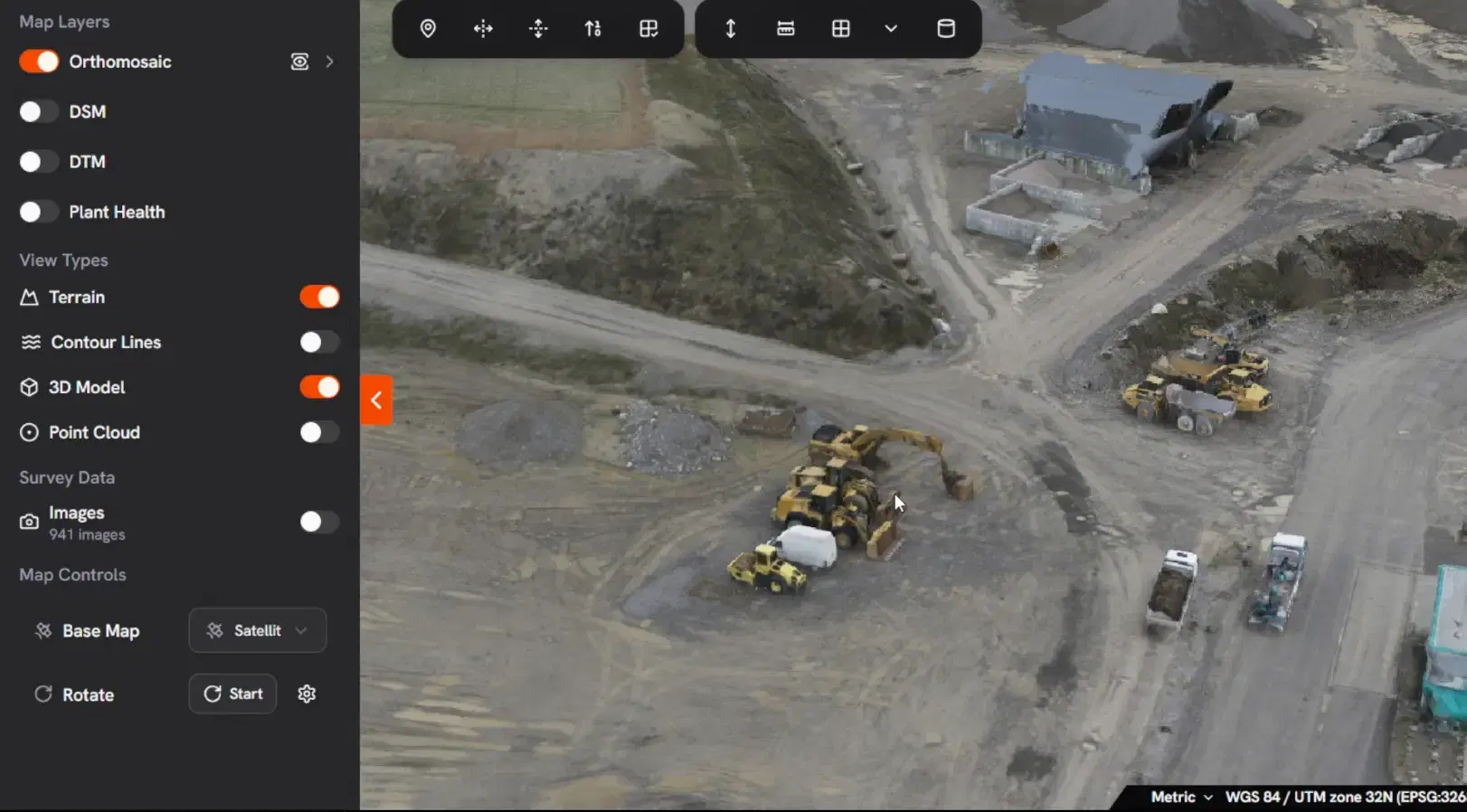
View your entire site in one place through any browser, with no software installation required. Ideal for teams reviewing aerial mapping results, orthomosaics, and 3D site data.
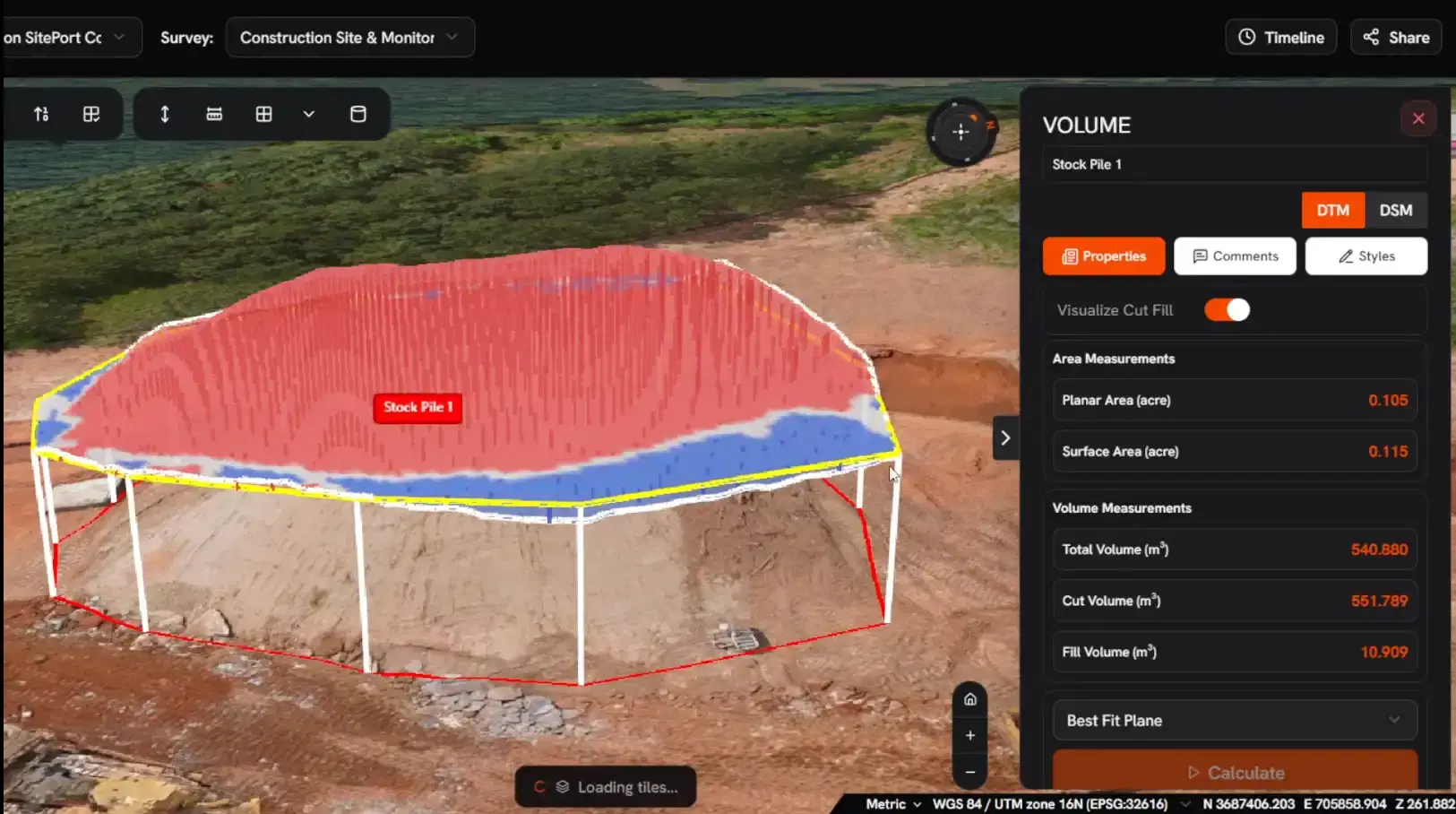
Measure with confidence using volume outputs validated against total station checkpoints, helping project teams rely on accurate drone surveying and mapping data for planning, billing, and progress monitoring.
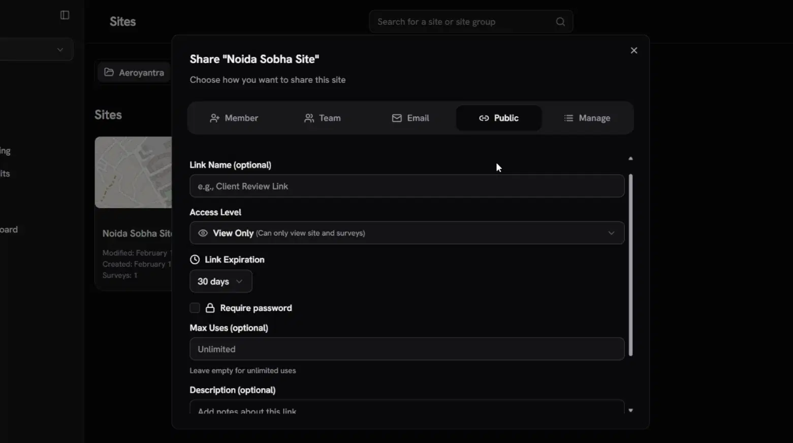
Send a simple link so clients, contractors, and consultants can review the same drone mapping and survey data without needing an account.
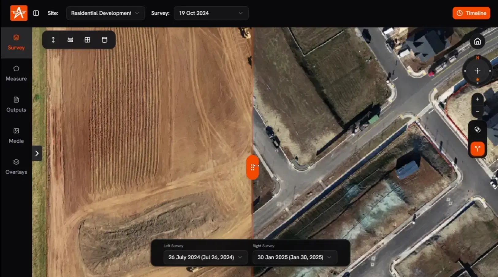
Compare surveys across dates to see what moved, how much changed, and where issues are developing before they affect cost, timelines, or project quality. This is especially useful for recurring drone survey services on active sites.
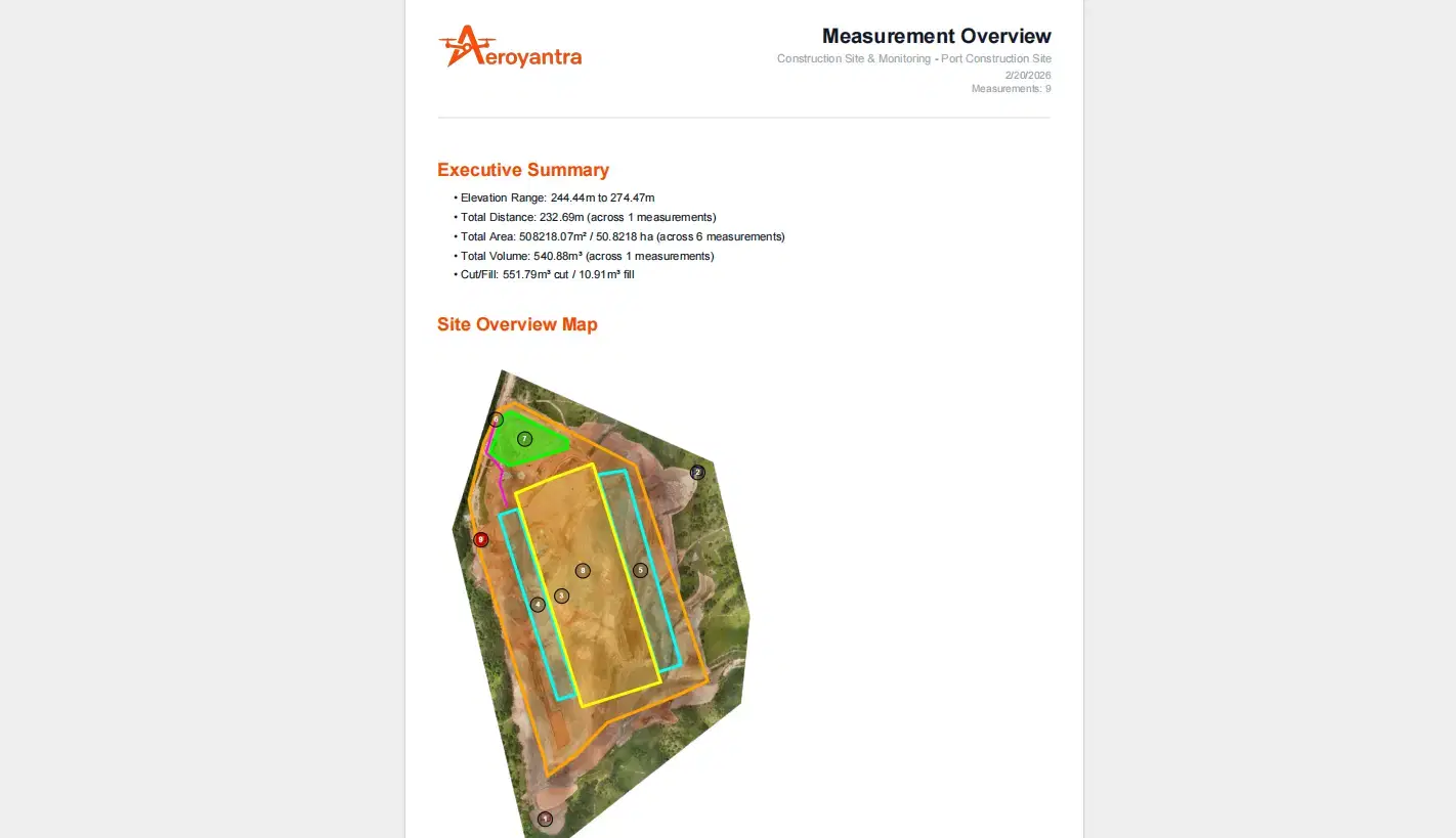
Get audit-ready reports and standard exports with the key files your next team needs for surveying, mapping, and GIS documentation, without additional follow-up.
Interactive Demo Sites
Open real survey environments inside our browser-based 3D platform and explore how drone survey mapping and aerial mapping services are delivered on real-world projects.
01 / 10
Use the Aeroyantra platform to process your own drone data, or let our team handle drone survey services in India and deliver results quickly with survey-grade outputs.
Track site changes, measure volumes, compare surveys, and share drone mapping insights with your team
We fly your site, process on our engine, and deliver actionable drone surveying and mapping reports in 48 hours
Tell us about your site and we'll recommend the fastest path to the drone survey, aerial mapping, or GIS mapping outputs you need.
Our DGCA-certified team handles everything - from flight planning to final deliverables. You don't need to own a drone, learn software, or hire a pilot.
These are our core deployment sectors. Explore the full industry catalog on the dedicated page.
Global usage footprint and processing scale demonstrated through live project operations.
Surveys Processed via Platform
Countries with platform users
Images processed
Case Study
How a large construction site shifted from manual surveys to recurring drone intelligence.
Read now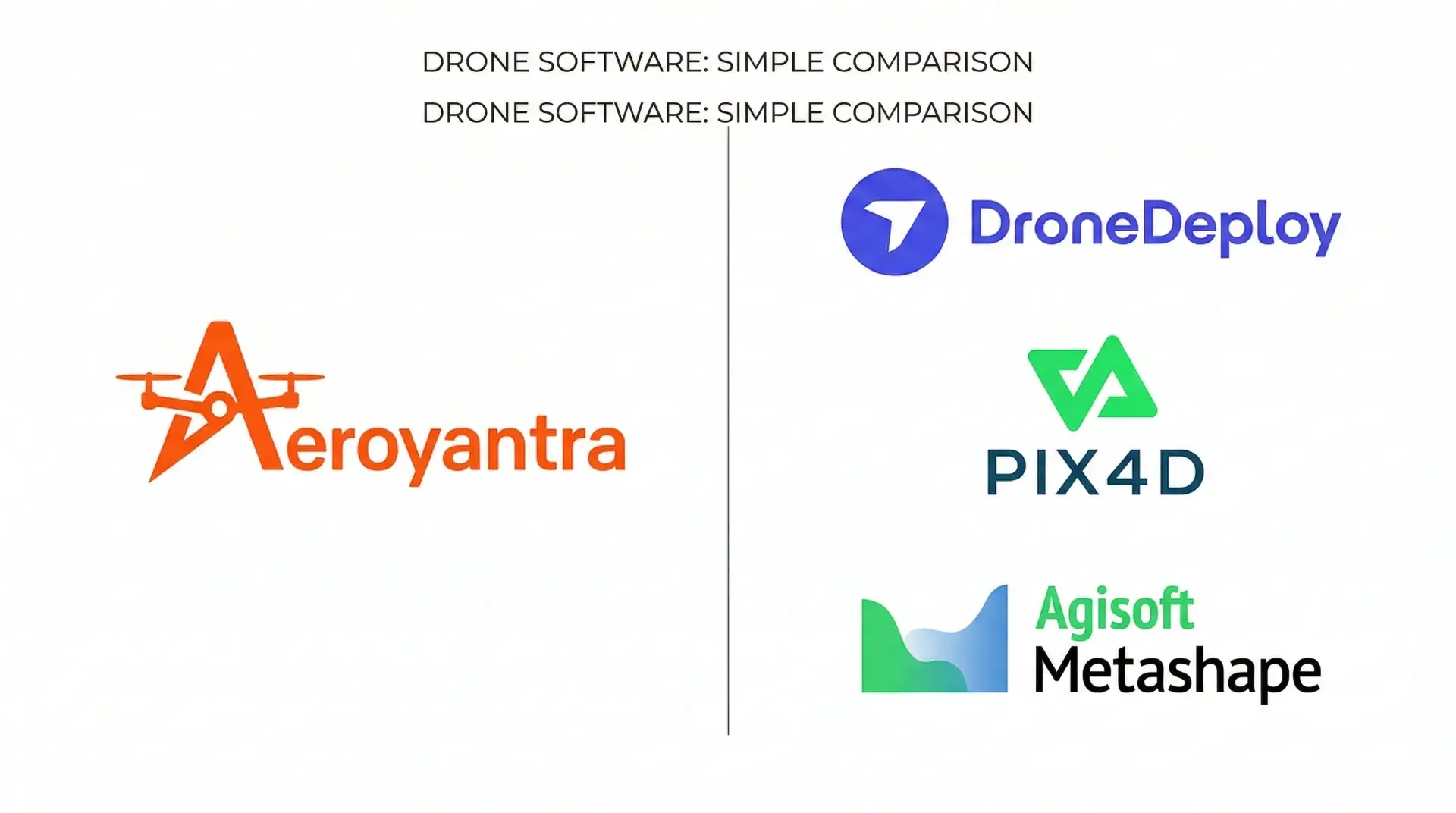
Pricing Analysis
Real cost comparison of global subscriptions versus pay-per-use processing.
Read now
Mining Guide
Specification-exact workflow for mining teams preparing annual drone submissions.
Read nowGet answers to common platform and survey-service questions
With RTK-enabled drones (DJI Mavic 3E, Matrice 350 RTK, Phantom 4 RTK) and proper GCP placement, Aeroyantra delivers 2-3 cm horizontal and 3-5 cm vertical accuracy - comparable to total station surveys for earthwork volumes, stockpile measurement, and site documentation. The difference is speed: what takes a ground crew 3-5 days to survey, a drone covers in a single flight and Aeroyantra processes in 2-4 hours. Our results are regularly validated against total station checkpoints on live mining and construction projects. For applications requiring sub-centimeter precision (structural setout, machine control), total stations remain the right tool - but for volumetrics, progress monitoring, and compliance documentation, drone photogrammetry delivers equal accuracy at a fraction of the time and cost.
Aeroyantra is significantly cheaper for most survey teams. Pix4D Cloud starts at $49/month (basic) to $249/month (advanced) with per-seat licensing - a 5-person team on advanced plans pays $1,245/month. DroneDeploy starts at $329/month per user, reaching $599/month for advanced features. Agisoft Metashape requires a one-time $3,499 license plus a high-end GPU workstation ($2,000-5,000). Aeroyantra charges $2.50 per gigapixel processed on Pay-As-You-Go, or $69/month for Professional with 40 credits included and unlimited users. A typical 500-image survey costs approximately $20 to process. There are no seat licenses - your entire team accesses the same account at no additional cost. For teams processing 10-20 surveys per month, Aeroyantra costs 60-80% less than Pix4D or DroneDeploy while delivering equivalent output quality.
Desktop photogrammetry (Agisoft Metashape, Pix4Dmapper) requires a dedicated GPU workstation ($2,000-5,000), ties up that machine for hours during processing, produces inconsistent results depending on operator settings, and makes sharing outputs difficult. Aeroyantra processes on cloud GPU clusters - you upload images from any browser, processing runs on our infrastructure, and results are ready in 2-4 hours regardless of your local hardware. A laptop, tablet, or phone is all you need. Results are consistent across projects because our proprietary engine applies standardized workflows. Sharing is instant: generate a view-only link and any stakeholder sees the 3D model, orthomosaic, and volume reports in their browser. No software installation, no license management, no workstation maintenance.
Unlike most drone mapping platforms that license third-party processing software (many cloud platforms are essentially resellers of the same underlying engines), Aeroyantra built its own photogrammetry pipeline from the ground up - feature extraction, bundle adjustment, dense point cloud generation, mesh texturing, and orthomosaic stitching are all written and maintained by our engineering team. This matters for three reasons. First, your data never leaves our infrastructure to be processed by external software vendors - complete data sovereignty. Second, we control processing quality and can optimize for specific use cases (mining volumes, construction earthwork, corridor mapping) rather than relying on generic third-party settings. Third, because we have no per-project software licensing costs, we pass that savings to you - which is why our pricing is 60-80% lower than competitors using licensed engines.
Most survey projects (up to 500 images) process in 2-4 hours. Small sites under 200 images can be ready in 30-45 minutes. Large datasets (1,000-5,000 images) typically complete in 4-8 hours. Processing speed depends on image count, resolution (megapixels per image), overlap percentage, and selected quality settings. Standard quality is fastest; high-density mode takes roughly 2x longer but produces denser point clouds for applications requiring maximum detail. Professional plan subscribers get priority GPU queue access, and Enterprise clients have dedicated processing nodes for guaranteed turnaround. If processing fails for any reason (insufficient overlap, corrupted images), you are not charged - credits are only deducted on successful completion.
Every processed project produces: high-resolution orthomosaic (GeoTIFF), Digital Surface Model and Digital Terrain Model (GeoTIFF), dense point cloud (LAS/LAZ), 3D textured mesh (OBJ/GLB), and contour lines (DXF/SHP). You can also generate volumetric reports (PDF/CSV), cross-section profiles (DXF), and cut/fill analysis reports directly in the platform. All outputs are georeferenced and export in industry-standard formats compatible with AutoCAD Civil 3D, Bentley OpenRoads, ArcGIS, QGIS, Maptek Vulcan, Surpac, Leapfrog, and Global Mapper. PDF reports can be customized with your company branding for client handover. You can also share interactive view-only links where stakeholders explore the 3D model, orthomosaic, and measurements in their browser without any software.
Any drone that captures geotagged images works with Aeroyantra. This includes DJI Mavic 3 Enterprise, Mavic 3 Multispectral, Matrice 30/300/350 RTK, Phantom 4 RTK, Mini 4 Pro, Air 3; fixed-wing drones like senseFly eBee, Wingtra WingtraOne, Quantum Trinity F90+; and industrial platforms from Freefly, Acecore, and Harris Aerial. We support standard RGB (JPEG/TIFF), multispectral, and thermal imagery. RTK/PPK drones improve absolute accuracy and reduce GCP requirements, but are not mandatory - any camera drone with GPS produces usable results. If your drone captures images with GPS coordinates in the EXIF data, Aeroyantra can process it.
For absolute accuracy of 1-3 cm, GCPs are recommended - especially for vertical accuracy on volumetric measurements, compliance documentation, and contractor payment verification. However, with RTK/PPK drones (Mavic 3E, Phantom 4 RTK, Matrice 350 RTK), you can achieve high absolute accuracy with just 1-2 checkpoints instead of a full GCP network, significantly reducing field time. For relative accuracy (comparing two surveys of the same site, tracking change over time, or measuring volumes between visits), GCPs are not mandatory if you use RTK/PPK drones with consistent flight parameters. Aeroyantra supports both GCP-based and direct georeferencing workflows, and our processing engine auto-detects GCP markers for faster alignment.
All data is encrypted in transit (TLS 1.3) and at rest (AES-256). Processing happens on cloud GPU clusters in secure data centers. Standard accounts use shared infrastructure with logical data isolation. Enterprise accounts can opt for private cloud or dedicated instances with data residency controls aligned to your jurisdiction and contract requirements. Role-based access control (Owner, Admin, Member, Guest) governs who can view, edit, or export project data. Activity audit trails track all user actions for governance and compliance. We provide security questionnaire responses and control summaries for enterprise IT and procurement review on request. Your imagery and processed outputs are never shared with third parties or used for training purposes.
Aeroyantra does not charge per-seat licenses. Professional plans include 3 users, and Enterprise plans include unlimited users at no additional cost. This is a fundamental difference from Pix4D and DroneDeploy, which charge per user - meaning a 10-person team on DroneDeploy Advanced pays $5,990/month in seat licenses alone. On Aeroyantra Enterprise, that same team pays one flat fee regardless of how many people access the platform. You can also generate unlimited view-only sharing links for external stakeholders (contractors, clients, regulators) at no cost - they view the 3D model, orthomosaic, and reports directly in their browser without creating an account.
No. Credits are only deducted on successful processing completion. If a job fails due to insufficient image overlap, corrupted files, or any processing error, your credits are not consumed. You receive a diagnostic report explaining the failure reason (typically insufficient overlap, blurry images, or inadequate GPS data) with specific recommendations to fix the issue. You can re-upload corrected imagery and reprocess at no additional cost for the failed attempt. Our processing engine also runs automated quality checks before starting - if your dataset has obvious issues (too few images, missing GPS data, extreme exposure variation), you are warned before credits are committed.
DroneDeploy is a strong enterprise platform with deep integrations and a large customer base. The key differences are pricing and flexibility. DroneDeploy Advanced costs $599/user/month with annual commitment - a 5-person team pays $35,940/year before any add-ons. Aeroyantra Professional costs $69/month with unlimited team access and pay-per-use processing. For construction teams running weekly or bi-weekly site surveys, the cost difference over 12 months is significant. Feature-wise, both platforms offer orthomosaics, 3D models, volume measurement, timeline comparison, and design overlay (DXF/BIM). Aeroyantra also exports directly to AutoCAD Civil 3D, Bentley, and ArcGIS formats. DroneDeploy offers deeper integrations with enterprise tools (Autodesk Build, Procore) and has a larger ecosystem. If your priority is cost-effective processing with survey-grade outputs and unlimited sharing, Aeroyantra is the stronger choice. If you need enterprise ecosystem integrations across 50+ projects, DroneDeploy may justify the premium.
Start with a free trial. No credit card required. Process your first site to see the quality yourself.
Need us to survey your site? .


