Turn Drone Data Into
Survey-Ready Reports
Upload images, get survey-grade accuracy orthomosaics, interactive 3D models & volume reports — all cloud-processed.
*1-2cm horizontal, 3-5cm vertical with GCP/RTK/PPK
Upfront / Recurring Cost
Pay only per survey per hectare processed
Cloud-Based
Process from anywhere, anytime
Hardware Needed
Save $20K+ on workstations
We know survey work shouldn't be this hard
These daily struggles are costing survey teams time, money, and peace of mind
External Challenges
- Costly hardware and software investments
- 6+ hours lost on manual calculations
- Endless re-work cycles
Time and money drain that kills project margins
Internal Stress
- Deadline stress and pressure
- Accuracy anxiety on deliverables
- Scaling and Quality Control challenges
Team burnout that affects quality and morale
Core Issue
- Complex workflows need expertise
- Professional mapping shouldn't be rocket science
- Simple surveys become technical nightmares
Technology should serve surveyors, not the other way around
What if there was a better way?
What if drone surveying could be as simple as upload, process, download? No complexity. No expensive hardware. Just accurate results.
That's why we built Aeroyantra
100% in-house AI photogrammetry pipeline
No third-party dependencies or data sharing concerns
Tuned for global terrain, weather, and specs
Optimized algorithms for monsoons, dust, and diverse geography
Faster and more cost-effective than imports
Eliminate licensing fees and currency fluctuation risks
Support by expert survey engineers
Real understanding of drone mapping challenges and requirements
Fly. Compute. Decide.
Three simple steps to transform your drone data into actionable insights
Upload
Drag & Drop Simplicity
Any Drone flight, any pattern, just upload
Process
AI-Powered Magic
Hit Process, grab coffee — AI handles it
Share
Instant Delivery
Links, PDFs, DXFs, CSVs — no installs
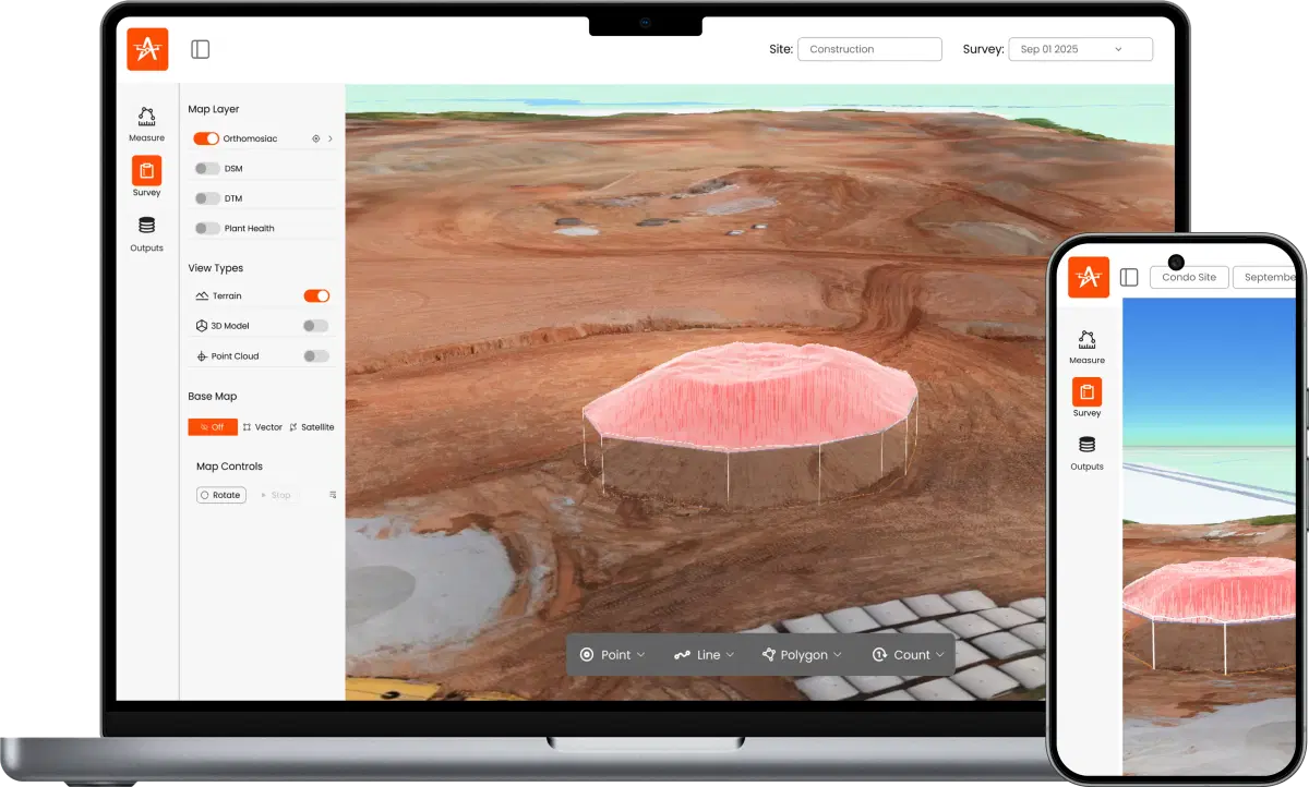
Explore a Real Mine Survey
View an actual 3D model of a mine site processed with Aeroyantra
Why surveyors switch to Aeroyantra
Join early adopters who've discovered the future of drone surveying
Save 6+ hours per site
Eliminate manual calculations and processing bottlenecks with automated workflows
No-charge reprocessing
Get it right the first time with consistent accuracy and quality control, if still unsatisfied reprocess free
Audit-ready in clicks
Generate PDF reports, DXF files, and CSV exports for compliance and handover
Survey-grade accuracy
2cm horizontal, 3-5cm vertical with GCP/RTK/PPK precision that meets surveying standards and client expectations
7× ROI within 60 days
Typical payback through time savings, reduced costs, and increased capacity
“Aeroyantra cut our monthly survey cycle from 5 days to 1 morning.”
Powerful Features for Modern Surveying
Everything you need to transform raw drone data into actionable insights
- Highway
- Lidar Survey
- Dumpyard
- Mining
- Agriculture
Smart Volumetrics
Auto-detect piles, export CSV to ERP
Seamless integration with existing systems
Cut/Fill Heatmaps
1m grid to surface deviations
Visual analysis for earthwork planning
Progress Timelapse
Weekly orthos; side-by-side compare
Track project evolution over time
Instant Cross-Sections
Drag a line; export to Civil 3D
Direct CAD integration for design work
Spectral and Multispectral Processing
NDVI, crop health & vegetation analysis
Advanced agricultural insights for precision farming
Shareable 3D Viewer
Open on any device, no install
Client presentations made simple
Want to see these features in action?
Still Evaluating?
Get answers to the most common questions about Aeroyantra
Drone photogrammetry accuracy depends on your GPS setup. With RTK-enabled drones, we deliver survey-grade accuracy down to -2cm horizontal, 3-5cm vertical with GCP/RTK/PPK. For standard GPS flights, expect 5-10cm horizontal and 10-15cm vertical accuracy - exceeding industry standards for construction, mining, and agricultural surveying applications.
Ready to transform your survey workflow?
Start with a free trial. No credit card required. Process your first site to see the quality yourself.